A renowned artist, once described as the “most imaginative artist that we have”, lived quietly near Upminster Common for over 75 years, unknown to most of the people of Upminster. The talents of Edna Clarke Hall – Lady Clarke Hall from 1932 – were largely ignored for decades after she was forced to give up painting in 1951 but in her later years her work was once again celebrated. Continue reading
Upminster Common Revealed: Part 1 – Bird Lane and around Tylers Common
To the Victorian Census Enumerators the whole area to the north of Upminster parish – north of the line of what is now the A127, the Southend Arterial Road – was referred to as “Upminster Common”. In earlier times the whole of this part of Upminster was all common land governed by Upminster’s two manors, Gaynes and Upminster Hall, but over time much of it was progressively enclosed and farmhouses, cottages and small holdings were developed.
Upminster’s lost brickworks
A century ago visitors approaching Upminster from the north down Hall Lane would have noticed several lofty chimneys and other industrial buildings behind what we now call the Strawberry Farm (but then known as Chapman’s or Potkiln Farm). This was Upminster’s brickworks which at its peak in the 1890s employed over 20 men and lasted into the 1930s. Continue reading
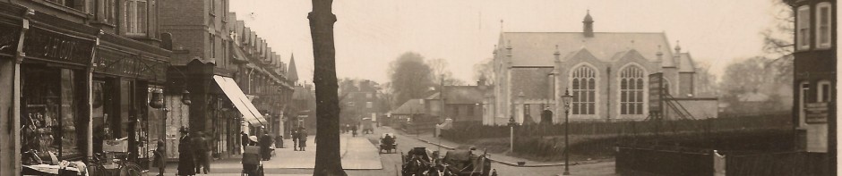
Upminster’s Cosy Corner (137 St Mary’s Lane)
Older residents recall with nostalgia Upminster’s Cosy Corner Café, which was a distinctive feature of the Bell crossroads until it was demolished by Hornchurch UDC in January 1957 in the name of “progress”, to make way for road widening and improvements to the junction. Continue reading
Posted in Upminster Buildings & Places
Tagged Bert Cockman, Cosy Corner, Edward Oakes, Old Butcher's Shop, Upminster
2 Comments
Eldred’s smithy
Visitors passing through Upminster and local people going about their business could not fail to see, hear and smell the popular working smithy at the heart of the village, adjacent to the Bell. For much of its existence the business was operated by members of the Eldred family, but while the Georgian Bell premises survived for almost two centuries, the adjacent smithy had a much shorter life span. Continue reading
The Bell Inn
The Bell Inn dominated the crossroads at the centre of Upminster for around 200 years until its demolition in the summer of 1963, to be replaced by a featureless parade of shops with an ugly car park above. These days it may well have been saved and given an imaginative renovation that breathed new life into the premises but in the early 1960s the conservation movement had not taken hold and we can only look back with nostalgia at what might have been. Continue reading
St Mary’s Lane, North side: Part 2 – from Garbutt Road to the Cosy Corner Crossroads
The article follows on from the last one which covered the eastern part of the north side, from the Cranham boundary to Garbutt Road. We therefore pick up the story at the west side of Garbutt Road, and continue westwards, towards the Bell/Cosy Corner Crossroads, a road frontage stretching some 400 yards which by the mid-1930s had been developed into houses and shops. How do a former “Public Enemy No.1” and a famous magician have links to here? Read on! Continue reading
St Mary’s Lane, North side: Part 1 – from the Cranham boundary to Garbutt Road
The earlier article about the south side of St Mary’s Lane ended at the Cranham boundary so that’s where this exploration of the opposite, north side starts. The south side had historically formed the New Place Estate, only developed for shops and housing in the 1920s and 1930s, but in contrast the north side was made of up a variety of plots of land in various ownership, developed in a piecemeal way over more than two centuries. This article covers the eastern part of the north side, from the Cranham boundary to Garbutt Road, approximately a 320 yard road frontage. Continue reading
Tales from the grave: the Rowe family of Upminster
I never planned to write this article! I fully intended to keep my promise to publish the history of the north side of St Mary’s Lane. But in local history research the path is rarely straight and narrow – it can lead you down dead ends or spring off in unexpected directions. So what started as research into a family who lived in St Mary’s Lane led me to detailed exploration of something quite different and revealed fascinating insights into Georgian Upminster. Continue reading
The Road to Cranham – Part 1 South Side
It’s almost half a mile from the main Upminster crossroads eastwards along St Mary’s Lane to the parish boundary with Cranham and although this now forms a continuous stretch of shops and houses, a century ago the stretch of road looked very different and remained a tree-lined country lane with few buildings, much as it had in throughout the Victorian era. The post is one of two that covers the development road once known as Cranham Lane – now St Mary’s Lane – and looks at the south side. Continue reading
