
Upminster has changed considerably in the past century.
When Queen Victoria died in 1901 it was still a country village with several large old houses, many of which had been built in the 18th century. But from the early 20th century Upminster was developed as a Garden Suburb which led to the village’s rapid expansion and modernisation. Development continued apace between the wars and these decades saw the loss of many of Upminster’s larger old houses such Great Gaynes, Hunts Farm, Foxhall and Hoppy Hall. Nevertheless, there have been survivals.
Old Upminster can be considered to be made of three distinct areas:
- the central village, along what we now know as St Mary’s Lane and the areas around the crossroads;
- the north of the parish, including Upminster (Tylers) Common; and
- the area to the south, around Corbets Tey and Hacton hamlets.

Upminster parish from Wilson’s 1881 History
The parish’s population was far-flung, being spread across a long thin parish of some 3362 acres, stretching some six miles north to south but no more than one mile wide, and just half a mile wide at its narrowest. Only 337 lived in the village centre in 1841, outnumbered by the 461 inhabitants living in the south, with a further 315, scattered around Upminster Common and the north.
What was usually described as Upminster Village was in fact little more than a series of houses and cottages along the road from the Hornchurch boundary in the west to the boundary with Cranham in the east. Much of this development took place in the late 18th or early 19th centuries
The first property from Hornchurch on the south side of Upminster Hill was the house later known as the “Red House” – this became the Drill Hall where the Territorial Army had its headquarters from 1930 and which survived into the 1960s. There were then three pairs of cottages erected 1780s demolished in 1909. Minster House School, built in 1792, in the 19th century housed a young ladies’ boarding school there. The Congregational Chapel was completed in 1801 and beyond this was Hill House – the original house and eleven acres of land had formed part of Hoppy Hall Farm and was much extended & remodelled between 1870-72 and renamed Hill Place.
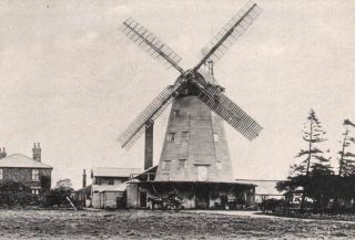
Upminster Windmill
On the north side, Upminster’s workhouse (now surviving as Ingrebourne Cottages) was built in 1750 and extended in 1786. Opposite Hill Place Upminster’s famous windmill had been built by James Nokes in around 1805 and was owned and operated by the Abraham family for almost 80 years.
At the south-east corner of the crossroads stood the 18th century Bell Inn and adjoining smithy while Sir James Esdaile’s mansion of New Place was the only premises between here and the boundary with Cranham. On the north side there were very few residences until piecemeal development started from the 1820s onwards.
South of the crossroads on the east side of Corbets Tey Road was the 16th century High House (where Byron Parade now stands) and further down was the terrace often known as Post Office Cottages and Hunts Farm, while opposite the only residence was Hoppy Hall.
The northern area was mainly made up of scattered farms and workers’ cottages around Upminster (Tyler’s) Common and Gaynes Common.
Upminster Hall and its estate included Chapmans and Martins Farms and also the brickworks – known as the Potkilns – around Bird Lane. Other farms included Pages Farm, Ivy House Farm, Tylers Hall Farm and Great Tomkyns. Until 1881 there was a windmill on Gaynes Common (near Ivy House Farm).
Great Gaynes
The main premises in southern area closer to the village were Great Gaynes, the adjacent Gaynes Villa, and the surviving Tadlows. Much of the population lived in the hamlet of Corbets Tey, the smaller hamlet of Hacton (including Hacton House) as well as other scattered farms and cottages. Larger houses include the former residence London’s, the surviving Harwood Hall, Great Sunnings and Little Sunnings (Sullens) Farms.
* * *
This section will be further developed to include information about key buildings & places in Upminster, past and present, such as:
- St Laurence Parish Church – see here
- Upminster Hall – see here

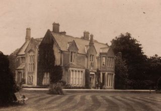
Upminster Court 1909
- Great Gaynes – see here
- New Place – for details of Sir James Esdaile’s mansion of New Place read here and for a description of life at New Place a century ago see here
- Hill Place (later Sacred Heart of Mary Convent) – see here
- Harwood Hall – see here
- Upminster Court – see here
- Upminster Windmill – see article on Upminster Hill
- Upminster Workhouse (Ingrebourne Cottages) – see article on Upminster Hill
- Upminster Garden Suburb – for W P Griggs & Co.’s development from 1906 see here.


is there a map of upminster showing where the old houses were and still ar
Hi David.
Old Ordnance survey maps can be found at https://maps.nls.uk/ or a map from 1777 can be found at https://map-of-essex.uk/
Several of the articles on this website have maps included.
Is there a photo of the old Territorial Army center in Upminster ?
I don’t have a close up but it’s in the background in pics on the Upminster Hill article https://upminsterhistory.net/2016/10/04/historic-upminster-hill/