It hardly seems possible that it is now 25 years since Upminster: the Story of Garden Suburb was launched with a book signing in the Roomes Store on Station Road, Upminster on Saturday 9th November 1996.
Continue readingUpminster Hall: manor and estate
At the Domesday Survey of 1086 Waltham Abbey’s Upminster manor was made up of the Abbey’s estate of around 340 acres, with another 1,200 acres of so of woodland. The male tenant population of 13 had four ploughs between them to carry out their obligations to work on the Lord’s land. These tenants were split into three categories: there were six “villeins”, who held the largest plots, possibly up to 30 acres, four “bordars” each with a smaller holding – perhaps five acres or so – and three “serfs” who either held a small plot of land, or none at all. The survey also recorded a “sokeman” – a tenant free of working on the Lord’s land – who held 30 acres and half a “carucate” (a ploughland – possibly around 60 acres).
Continue readingSeven Years!
It was seven years ago today, on 21 December 2013, that I launched this Upminster website and here we are 35 lengthy blog posts, around 100,000 words and around 70,000 website hits later we’re still going strong. When I started, after 20 years of researching Upminster’s past, I don’t think I ever imagined where this journey might take me but here we are, almost at the end of 2020, far more advanced than I would have guessed.
Continue reading
Posted in Uncategorized
4 Comments
The Branfills at Upminster Hall
The aftermath of the recent Black Lives Matters protests has thrown a spotlight on historic figures who had links with the slave trade. Upminster has not escaped this scrutiny which has brought to light unpleasant local connections with the Branfills of Upminster Hall and a call for a road and a school in Upminster to be renamed to erase these links. Continue reading
Posted in Upminster People & Events
Tagged Andrew Branfill, Benjamin Branfill artist, Branfill, Braund family, Champion Branfill, Champion slave ship, Guinea man, John Harrison EIC, Rev James Bearblock, Robert James East India Company, Royal African Company, Upminster Hall, Upminster Hall Manor
10 Comments
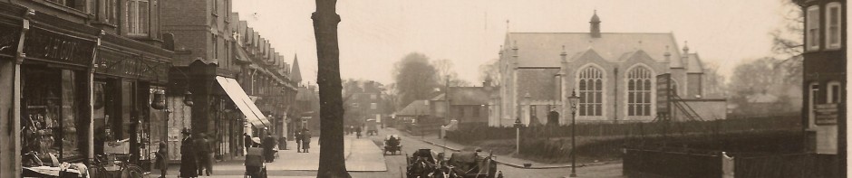
Big houses and farms around Corbets Tey
The two previous items about Corbets Tey have looked at the village and the area around Hacton. This third piece looks at four large houses and farms around the village centre, three of which still survive, and shines a light on Upminster’s ancient origins. Continue reading
Around Corbets Tey: Hacton Hamlet
The populous Upminster hamlet of Hacton seems to be one of three clusters of medieval settlement in the parish, the other two being the village centre and Corbets Tey. The area was to the west of the Gaynes manor estate and centred around where Little Gaynes Lane met Hacton Lane as it climbed up from Hacton Bridge towards Aveley. Continue reading
Corbets Tey Village
During much of the Victorian era the hamlet of Corbets Tey supported three alehouses, and boasted a full range of local services including a Post Office, butcher, baker, a grocer and drapers, as well as two carpenters, a blacksmith, wheelwright, a boot and shoemaker and for a while a boys’ boarding school. Continue reading
Posted in Upminster Buildings & Places
Tagged Bearblock's Cottages, Cabbage Corner, Corbets Tey, Henry Suckley Charity, High House Corbets Tey, Huntsman & hounds, John Saunders' boarding school, Keelings, Mary Freeman Shepherd, Michael Fallet, Rev James Bearblock, Sir George Wharton, Smithy Corbets Tey, The Anchor, The George
23 Comments
Upminster Common Revealed – Part 2 – Gaynes Common and south from the Four Want Way
Gaynes Common – otherwise known as Mill Common or Upminster Common – lay to the west of Nags Head Lane and north and south of what is now known as Shepherds Hill. This common extended to almost 70 acres in 1842, and was where the tenants of the Manor of Gaynes could exercise their rights as commoners which included grazing their livestock. Continue reading
Posted in Upminster Buildings & Places
Tagged Derham's spring, Four Want Corner, Gaynes Common, Gaynes Mill, Good House Farm, Greathouse, Harold Court, Harold Wood, Ivy Lodge Farm, Martin's farm, Northlands or Hawes Farm, Padfield's Dairy, Pages Farm, Pinchon family, Poddies Farm, Shepherd & Dog, Sir William Clarke Hall, Upminster, Upminster Common, Upminster Windmill
8 Comments
