Category Archives: Upminster Buildings & Places
Corbets Tey Village
During much of the Victorian era the hamlet of Corbets Tey supported three alehouses, and boasted a full range of local services including a Post Office, butcher, baker, a grocer and drapers, as well as two carpenters, a blacksmith, wheelwright, … Continue reading
Upminster Common Revealed – Part 2 – Gaynes Common and south from the Four Want Way
Gaynes Common – otherwise known as Mill Common or Upminster Common – lay to the west of Nags Head Lane and north and south of what is now known as Shepherds Hill. This common extended to almost 70 acres in … Continue reading
Upminster Common Revealed: Part 1 – Bird Lane and around Tylers Common
To the Victorian Census Enumerators the whole area to the north of Upminster parish – north of the line of what is now the A127, the Southend Arterial Road – was referred to as “Upminster Common”. In earlier times the … Continue reading
Upminster’s lost brickworks
A century ago visitors approaching Upminster from the north down Hall Lane would have noticed several lofty chimneys and other industrial buildings behind what we now call the Strawberry Farm (but then known as Chapman’s or Potkiln Farm). This was … Continue reading
Upminster’s Cosy Corner (137 St Mary’s Lane)
Older residents recall with nostalgia Upminster’s Cosy Corner Café, which was a distinctive feature of the Bell crossroads until it was demolished by Hornchurch UDC in January 1957 in the name of “progress”, to make way for road widening and … Continue reading
Eldred’s smithy
Visitors passing through Upminster and local people going about their business could not fail to see, hear and smell the popular working smithy at the heart of the village, adjacent to the Bell. For much of its existence the business was operated … Continue reading
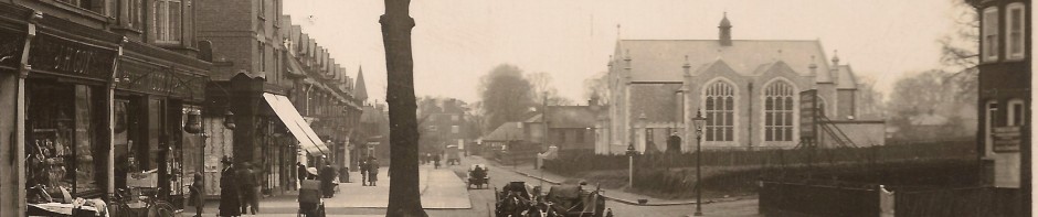
The Bell Inn
The Bell Inn dominated the crossroads at the centre of Upminster for around 200 years until its demolition in the summer of 1963, to be replaced by a featureless parade of shops with an ugly car park above. These days … Continue reading
St Mary’s Lane, North side: Part 2 – from Garbutt Road to the Cosy Corner Crossroads
The article follows on from the last one which covered the eastern part of the north side, from the Cranham boundary to Garbutt Road. We therefore pick up the story at the west side of Garbutt Road, and continue westwards, … Continue reading
St Mary’s Lane, North side: Part 1 – from the Cranham boundary to Garbutt Road
The earlier article about the south side of St Mary’s Lane ended at the Cranham boundary so that’s where this exploration of the opposite, north side starts. The south side had historically formed the New Place Estate, only developed for … Continue reading
The Road to Cranham – Part 1 South Side
It’s almost half a mile from the main Upminster crossroads eastwards along St Mary’s Lane to the parish boundary with Cranham and although this now forms a continuous stretch of shops and houses, a century ago the stretch of road … Continue reading
