
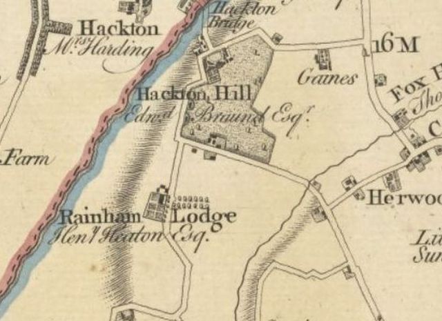
The populous Upminster hamlet of Hacton seems to be one of three clusters of medieval settlement in the parish, the other two being the village centre and Corbets Tey. The area was to the west of the Gaynes manor estate and centred around where Little Gaynes Lane met Hacton Lane as it climbed up from Hacton Bridge towards Aveley.
Reaney’s The Place-Names of Essex suggests that the name Hacton described a settlement which grew up on a tongue of higher land (from the Old English haca) between the Ingrebourne and one of its minor tributaries. However, Reaney’s explanation is almost certainly wrong as it totally ignores the fact that the area on both the Hornchurch and Upminster sides of the Ingrebourne are known as Hacton. Other evidence suggests that the references he cites from the early thirteenth century were to features in Hornchurch, not Upminster. The terms Haketon or Hacton and Hakeforde or Hackford were both in common use from the thirteenth century onwards. Hackford may derive from the road crossing the River Ingrebourne (Old English Hacca Ford – hooked or bent river crossing) or alternatively Hacton may refer to a settlement (OE tun) from an early individual named Haca.
Archaeological evidence has confirmed very early habitation on both sides of the Ingrebourne in this area. In Upminster crop marks to the west of Hacton Lane indicate an ancient enclosed settlement and related field systems here, and two hoards of metalwork found nearby have been dated to the Late Bronze Age (c.1020-c.800 BC).
There seems to have been a thriving Hacton community in later years. A manorial survey for Gaynes in 1704 identifies 15 separate named small land holdings on the Upminster side, which may have originally been separate tenanted crofts or holdings in the medieval period, later assembled into larger plots.

Hacton Farms and main estates 1841 Map courtesy of Andy Grant (c) 2019
The principal residence, now known as Hacton House, was originally known as Hactons or Hacton-on-the-Hill to distinguish it from the Hacton House on the opposite side of the Ingrebourne in Hornchurch, which appears to have been demolished in the 1780s.

Mary Branfill (nee Braund). from TL Wilson (1881)
Upminster’s Hacton House was built at this junction between 1762 and 1765 by William Braund (1695-1774), a Portugal Merchant and Director of the East India Company and the Sun Insurance Office. His Devon-born father Benjamin Braund, a London vintner, had retired to Upminster where he died at Corbets Tey in 1734. Benjamin Braund’s links to Upminster probably came from his acquaintance with fellow Devonian Captain Andrew Branfill of Upminster Hall and in 1711 Braund’s daughter Mary (1693-1760) married Branfill’s eldest son Champion (1683-1738). Mary was said to be a great beauty, known as the “Belle of Essex” and aged just 17 when she married in 1711 she went on to bear Champion Branfill 12 children between 1712 and 1734.
William Braund often lived with his sister Mary at Upminster Hall after she was widowed in 1738 until her death in 1760. However, after a quarrel with her son Champion Branfill William decided to build his own house. The site he chose was a small farm at Hacton, known as the Cock or Mealmans and Skinners Croft which he seems to have bought before 1758 from his sister, who must have acquired it from her son Benjamin, who inherited it from his uncle Andrew Branfill in1750.
Andrew Branfill had inherited this property in 1731 from his Aunt Alice Aylett, whose monument is in St Andrews Church, Hornchurch and who left a bequest to fund a school for poor boys in that parish. Alice had bought Mealmans and Skinners Croft and other properties in Hornchurch some 30 years before from a Mrs Katharine Hollman for £486.

Hactons from TL Wilson (1881)
It was on this corner site that Braund built for himself a gentleman’s house which cost over £4,400 over a three-year period. Braund’s surviving accounts show that from July 1762 onwards, he paid a Mr J Burrell five guineas for plans, presumably for the house, and regular payments of £200 or £250 to one Michael Babb, no doubt the builder, with the final payment made in July 1765 – a total of around £2,650. He may have managed the project himself and his accounts show direct payments to painters, plumbers, carpenters, masons, upholsters and other tradesmen adding another £1,750 to the total costs.
The Palladian-style Hacton House was described in 1841 as “substantially erected, and in excellent order throughout, possessing every convenience for a family of high class and respectability”. It boasted “six airy bed chambers” on the upper storey, with another three bedrooms, a library or morning room, a dressing room and a WC on the first floor, “a light cheerful vestibule” used as a summer room, and a wing with a large bedchamber, dressing room and another WC. The ground floor was graced by a “handsome hall”, an “elegant staircase” and stuccoed walls “enriched with foliage, fruit, and flowers” together with a breakfast parlour, library, dining room and a drawing room and “below stairs” were the engine house and servants premises to run such a mansion while outside were spacious stables, coach houses, kennels, cow houses, piggery and poultry house.
Forty years later Wilson described it as “a spacious well-proportioned red-brick building, with stone-quoins and dressings”. A flight of stone steps led to a portico and the “very effective façade” was graced by a “somewhat imposing balustraded parapet and cornice”. The carriage drive to the house ran from Little Gaynes Lane on the east and Hacton Lane on the west. This Hacton House estate comprised some 23 acres in 1841, with eight acres around the house, and a further 15 acres opposite, east of Hacton Lane and north of Little Gaynes Lane.
In the words of his biographer Lucy Sutherland:
Hacton, his solid, well-built, mid-Georgian house in Essex, with its fine staircase, its square rooms of a size domestic rather than spacious, its heavy doors with their double bolts, its park and its well-stocked kitchen garden, gives an impression of sober prosperity and good husbandry. It is the property of a man who has done well, who knows and likes the pleasant life of the English country house, but who, when he comes to live it himself, has no intention of wasting his hard-earned wealth in profusion of living.
Braund seems to have set out to progressively own all the land surrounding his Hacton estate and his wealth seems to have persuaded the land owners to sell. After buying nearby 18 acres of lands called Sanders for £500 from Thomas Wright of Hornchurch in April 1762, Braund added a further 10 acre holding called Watts alias Shillings from John Wolveridge for another £500 two months later.
In April 1765 Braund bought the adjacent 66-acre Park Corner Farm from Richard Lockley for some £1,200, and two years later laid out a further £1,400 to buy another nearby 30-acre farm from Charles Hornby. Two further fields followed for £1,000 in 1768 and Braund’s Upminster purchases concluded in December 1771 when he laid out £957 for another four fields, directly to the east of Hactons, part of Sir James Esdaile’s Gaynes estate as part of a transaction which involved selling Hunts Farm to Esdaile for £3,052. In total between 1762 and 1771 Braund spent some £5,600 on acquiring land in Upminster in addition to the £4,400 spent building Hacton House.
Despite his property deal with Esdaile, a few years later the pair became locked in dispute when after Braund enclosed and fenced off a piece of land in front of Hactons, which was part of the Gaynes manorial waste, Esdaile’s steward ordered this fencing to be removed. Braund retaliated by taking down a fence that Esdaile had put up around a watering place opposite his New Place home in Cranham Lane. Peace was restored when Esdaile backed down and allowed Braund to put back the fence at Hactons.
Extract from Chapman & Andrew Map of Essex . 1777
The grounds of Hactons seem to have been landscaped after William Braund’s death. Braund’s accounts show no expenditure on landscaping and Chapman and Andre’s map published in 1777 reflect this. However, the first edition Ordnance Survey Map, surveyed 1797-99, shows a large ornamental lake in the grounds to the south of the main house.
The earliest image of Hactons is an engraving in 1797 by Humphrey Repton, the famous local landscape gardener. Although there is no evidence to show that Repton executed the work, he may have produced the sketch for a commission enquiry. The landscaping may have been during the occupancy from 1787 into the early 19th century of Sir Thomas Barrett-Lennard who in 1803 hosted a grand review of the Barstable and Chafford Hundred Cavalry Troop, of which he was the Captain, in the parklands around Hactons. This occasion was described by Wilson as a “red-letter day” with everything being carried out on “an extensive and liberal scale”.
William Braund was a bachelor and after he died in March 1774 under the terms of his will Hactons passed to his nephew and protégé Benjamin Branfill, who also died without issue in 1780. Braund’s will specified that his estates should then pass successively through named male relatives. William Russell, another of Braund’s nephews, succeeded Benjamin Branfill, and after his death in 1810, the estates then passed in turn to his brothers John (d. 1825) and Joseph on whose death in 1828 Benjamin Pead inherited. Pead’s estates were sold after his death in May 1841 when Hacton House was bought for £2,450 by the Rev Richard Battiscombe, Rector of Southmere, Norfolk. After Battiscombe’s death in 1873 Hacton House was sold in April 1874 to William Irlam (d.1890), a retired engineer. His niece Alice Robertson lived there until her death in 1916 and then his nephew, Alfred William Irlam (d.1936). The graves of William Braund, the Rev Battiscombe, William Irlam, Alice Robertson and Alfred William Irlam, can be found alongside the path just outside the entrance to St Laurence’s Church.

Hacton House in the 1930s.
It’s likely that Hacton House stood empty after Alfred William Irlam’s death in 1936. During the Second World War it was requisitioned for use as an officers’ mess for airmen at Hornchurch airfield, leaving it in poor condition. There is some evidence that in 1948 the single storey wings to either side of the main house, which had previously housed the servants’ quarters and other non-domestic offices, were demolished retaining only the original façade, behind which modern bungalows (Numbers 1 & 4) were built.
There is also evidence that the panelling and fireplaces of at least one room from Hactons, the drawing room, were removed and shipped to America in or before 1948, when they were acquired by Summerfield G. Roberts of Dallas, Texas. Unable to find a skilled craftsman to install these in his own home, in 1957 Roberts donated the room to Alton Oschner Medical Foundation, from whom it was bought in 1959 by the newly-established Anglo-American Art Museum, part of Louisiana State University. The “Green Drawing Room” from Hacton was installed in the Museum as one of a number of similar recreated rooms. The room’s dimensions, some 22 feet by 18 feet, match the dimensions of the Hacton drawing room listed in an advertisement in 1893. Unfortunately, this room is no longer on display as when the Museum – now known as the Louisiana State University Museum of Art – relocated to new premises in 2005 the period rooms were not reinstated. They were crated and stored and at some time in the future they are set to be de-accessioned and sold, pending the legalities involved.
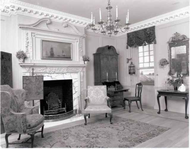
The Green Drawing Room from Hacton when installed at the Anglo American Museum of Art, LSU. Courtesy of LSU Museum of Art
Hacton House again remained empty post-War and in 1954 it was described by Pevsner as “partly ruined”. That same year it was considerably altered with the red-brick façade being rendered, the main building converted into flats (Numbers 2 & 3 Hacton House), and the roofline significantly altered to provide windows for the attic storey, destroying the original Palladian design. These post-War changes meant that although the house is locally listed it did not receive formal heritage registration despite now being over 250 years old. Plans approved in 2011 to restore the main building were never implemented.

Hacton House, January 2020
The only part of the Hacton House estate to be developed is the area to the east of Hacton Lane: Hornbeam Avenue, Aspen Grove and Lime Avenue were all laid out before the 1939 war but only completed afterwards, as was the Optimist Pub (opened 1956).
Opposite Hacton House, on the west side of Hacton Lane running down to the River Ingrebourne, was Tyler’s Farm, some 37 acres in extent which Benjamin Pead bought in 1789 from Francis Henry Tyler. Wilson said that an old cottage, the remains of a house called Tylers, which stood opposite the western lodge of Hactons, was removed around the mid-1830s. Tylers Farm had previously been owned by Francis Prujean of Hornchurch. After Benjamin Pead’s death in 1841 Tylers Farm was bought at auction by Thomas Mashiter of Hornchurch Lodge, on whose death without heirs in 1862 the estates were bequeathed to several named male relatives, under a complicated will which required his heirs to adopt the surname Mashiter. These estates descended under the terms of his will until they were sold for development in 1934 along with the Hornchurch Hacton Farm estate. While the latter was developed as the Racecourse Estate on either side of Hacton Lane, plans to similarly develop Tylers Farm – the Upminster part – did not proceed.
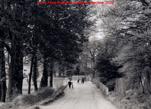
Looking across Hacton Bridge towards Hornchurch c. 1910
Hacton Bridge, which crosses the River Ingrebourne, the boundary between Hornchurch and Upminster, is known to have existed in 1299. Like the other two parish bridges (Upminster Bridge and Cocklebone or Cockabourne Bridge in the extreme north-west of the parish at Upminster Common) the upkeep of Hacton Bridge was a source of frequent contention in earlier times. However, unlike the other two bridges, it had originally been a manorial bridge maintained by Gaynes so the maintenance charge did not fall on Upminster parish. In the 1660s it was a horse-bridge but soon afterwards the carpenter in charge of its repair was persuaded by the inhabitants of Barstable and Chafford Hundreds to reinforce it for heavier cart traffic as the road was then being used to take corn to Romford Market. In 1674 the Essex Quarter Sessions ordered the cart bridge to be retained with the county paying two-thirds of the upkeep, despite objections by the Lord of Gaynes Manor, who only had to pay a third. Hacton Bridge was said to be out of repair in 1685 but it was only in 1728 that it was replaced by a more permanent brick bridge.
It seems that the Upminster parish vestry was unaware of the shared responsibilities and paid for all repairs between 1773 and 1820. In 1828 the County carried out a full review about whether or not the bridge needed to be pulled down and replaced, but decided against it as James Esdaile, the Lord of the Gaynes Manor refused to pay his share. By 1857 the County were totally responsible for the bridge’s upkeep and they carried out repairs and widening on the approaches in May 1874, and after floods caused damage in both 1880 and 1888.
The 16th century Park Corner Farm, on Park Farm Road, was destroyed by bombing in October 1940, although a Grade 2 listed mid-18th century barn with later external alterations survives. In 1841 Park Corner was described as a “very neat commodious Farm House” and 1910 it was said to have five bedrooms and two sitting rooms, although all buildings were described as “old and worn out”.
The farmlands were 66 acres in the early 18th century, comprising a 36-acre copyhold farm called variously, Park Corner, Hugh Bushes and Devenishes and a freehold part known as Bushy Crofts and Clements. William Frith was the owner in 1684 and it passed down through his son and grandson of the same name over the next 25 years. John Radford “mealman” of Westminster owned Park Corner from 1712 to 1724 when he left it to Tudor Lockley of Stepney, from whose son Richard Lockley William Braund bought the 66 acres farm in 1765, adding some of the other parcels of land bought by him to it. By 1799 Park Corner Farm, as it was now known, was 121 acres in extent and by 1841 it had grown by a further 20 acres to 141 acres. These additions included the four fields (some 23 acres) bought from Sir James Esdaile in 1771 and a further 38 acres lying west of Hacton Lane down to the River Ingrebourne.

Park Corner Farm c. 1910
The farm’s ownership then passed down in the same way as Hactons (see above). On Benjamin Pead’s death in 1841 it was bought by Thomas Agar and when he died three years later his brother-in-law Richard Bright of Orsett became the owner. Henry Druce then owned it after Bright’s death in 1879 and leading up to World War 1 and afterwards the owner was Richard Druce, probably his brother.
Park Corner Farm was usually let out to a local farmer. Its tenants included John Nicholls in the early 18th century and Richard Higgs from 1787 until 1802. Henry Joslin senior (father of Henry Joslin of Gaynes) then leased Park Corner farm, staying until his move to Hoppy Hall in 1841. Walter Knight, market gardener, farmed there from the late 1890s until his death in 1928 – his grandson Peter Hills, who was born at Park Corner Farm in 1917, recorded his childhood memories about growing up there in his memoir “Hacton in the 1920s” as did his younger sister Joan (b.1922) in her memoir “Tadlows and other memories” – both memoirs are in Upminster in Living Memory (2000). In 1995 Park Corner Farm was converted into an Equestrian centre which occupies 42 acres of the original farmlands south of Hacton House.
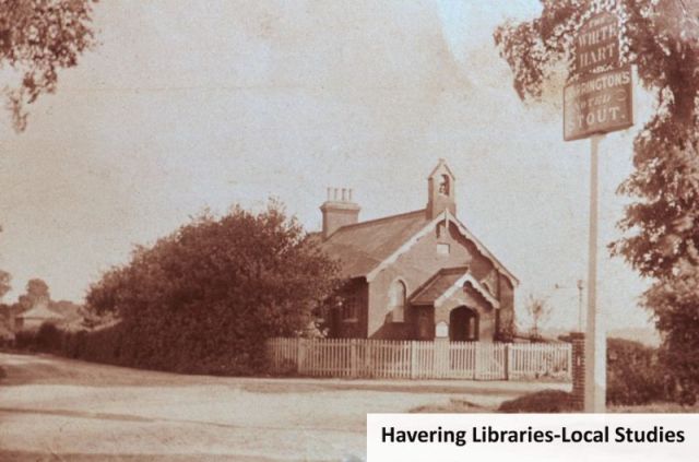
The White Hart beerhouse was formed from two labourers’ cottages at the corner of Hacton Lane and Berwick Pond Road in 1854 or 1855. The first landlord Peter Morris had been coachman to Major Crosse of Rainham, and he was succeeded by his wife. It later became a Charringtons public house but the license seems to have changed hands regularly in the 1890s. In August 1903 Charles Cooper the landlord there had the dubious notoriety of being summonsed before the magistrates for persistent cruelty to his wife; the license was transferred to Henry Emblin later that month. William Keeling Brazier was the publican from 1915 until his death in 1936 when his widow Ellen took on the license. By September 1939 Alexander Coombs was the licensee. The pub was rebuilt in 1962 and various improvements carried out in later decades to improve its attractions but the remote location, lack of public transport links and poor reputation meant that the pub was no longer a going concern and in December 2011 a change of use to residential was approved.

Believed to be WK Brazier outside the White Hart. Courtesy of Havering Libraries Local Studies.
The relatively large but remote Hacton community often had difficulty reaching the centre of the village and attending St Laurence’s Church, particularly during the winter. The Hacton population numbered some 99 in the 1911 census living in in 22 dwellings but by 1939 had fallen to 67 at lodges which had been added at Hacton House, Numbers 1 to 9 Hacton Cottages, Nos 1 & 2 Druces Cottages and 1 – 3 Park Corner Farm Cottages. In the 1920s & 1930s transport was arranged to take the children to the village school by lorry driven by Ernie Brazier, son of the publican of the White Hart.
A brick mission hall was built on the opposite corner to the White Hart in 1872, and although it was just across the border with Rainham it mainly served the Hacton community on the Upminster side of the boundary as a chapel and Sunday School. It seems to have been built by the owners of nearby Rainham Lodge, and was offered for sale with this premises in 1891. It may originally have been linked to St Helen’s & St Giles, Rainham but by 1907, the new Rector at Upminster, Rev. Henry Hyla Holden took over the chapel as a mission from St Laurence’s. Peter Hills, in his memoir, gives its name as St Chad’s Mission, and he listed members of the congregation who had signed a testimonial to his Aunt May Knight on leaving the farm in October 1928.
St Chad’s Mission Hall. Courtesy of Havering Libraries – Local Studies
The next instalment about south Upminster will follow in the near future (Corbets Tey – Part 3 – Big Houses and Farms). See also Part 1 Corbets Tey Village.
Particular thanks to Andy Grant for producing the Hacton map and also to him and Tony Fox for many helpful comments on the draft.
Also many thanks to Olivia Johnson of the Louisiana State University Museum of Art in Baton Rouge for providing information from their accession files on the Green Drawing Room from Hacton House.
Main Printed Sources:
Tony Benton (ed.) Upminster in Living Memory (2000) pp51-64 and 75-92
Thomas Lewis Wilson Sketches of Upminster (1856) pp78-86
Thomas Lewis Wilson History & Topography of Upminster (1881) pp150-154
Lucy Stuart Sutherland A London Merchant, 1695-1774 (1933)
Victoria County History Vol 7 (1978) Upminster pp.143-163
The Story of Upminster Book 3 p19, Book 5 p9-14
Isca Howell and others Archaeological landscapes of east London Museum of London Archaeology Monograph 54 (2011) p41-44
Main Archive Sources
Essex Record Office:
- Cash books (1747-1774) and accounts (1758-1774) of William Braund– D/DRu B2-B4
- Manor of Gaynes – Court Books 1678-1847 – D/DZb 1 & 2
- Sale Catalogue – Hacton House, Hacton Farm and Tylers Farm (1841) – D/DJn E1
Havering Local Studies:
- Correspondence concerning Hacton House (1964) – LF 108/12
- Abstract of Title – Hacton Farm & Tylers Farm 1852- 1939 – PL/HOR/20

Absolutely amazing information. I never knew we had so much history!
Pingback: God’s Acre – St Laurence Churchyard | Old Upminster