
The part of Upminster which stretches south from Corbets Tey, bordered on the west by Rainham, by North Ockendon to the east and Aveley to the south and south-west, has few inhabitants and a landscape scarred by past and present gravel pits. However, an important meeting place for 14 Essex parishes was here once and archaeological excavations have uncovered sites of national and regional historical importance.
Most of this area lies on a terrace known as the Corbets Tey gravels, laid down by the Thames in the lower and middle Palaeolithic era from c. 350,000 to 250,000 BC. Lying at about 15m-20m above sea level the area was ideal for early settlement as archaeological discoveries here and at other Upminster sites such as Great Sunnings, Harwood Hall and Hacton have confirmed. There has also been a rich series of discoveries in neighbouring Rainham, including the recently discovered late bronze-age “Havering Hoard”.
During the late Saxon period areas below shire or county level were grouped administratively into “hundreds”, which carried out certain functions, mainly ceremonial. Upminster was in Chafford Hundred, which stretched for around 13 miles northwards from the Thames marshes to the clay uplands at South Weald. Parishes were formed in the thirteenth century and Chafford Hundred contained Aveley, Cranham, Rainham, North and South Ockendon, Little and Great Warley, Grays and West Thurrock, Childerditch, South Weald (which included the hamlet of Brentwood), Stifford and Wennington, in addition to Upminster, the largest parish in the Hundred.
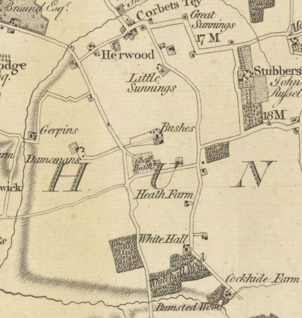
Hundreds held primitive courts at a fixed meeting place, usually an area of common ground where the main roads from the various parishes converged. Chafford Heath was an ideal location, at the junction of what is now Aveley Road and Bramble Lane, where the road from the upland parishes ran down through Upminster and Corbets Tey to converge with routes from the parishes in Chafford Hundred to the east and west – from modern Thurrock and Rainham respectively.
Chafford Heath seems originally to have been the southern common of Gaynes Manor where the manorial tenants could graze their livestock. A road from Romford to Stifford ran across this common, cutting off the corner from Aveley Road to Bramble Lane. In 1611 Thomas Frith, a local landowner and London scrivener, was summonsed before the county Quarter Sessions for enclosing the six-acre heath with hedges, ditches and barred gates, preventing the commoners from their grazing rights and stopping traffic from using the highway. Two years later a similar case was brought against Frith and William Harris or Harrison of Hornchurch after which it seems that access for the commoners and travellers was re-established. This road was still shown as a main route on Chapman & Andre’s map of 1777, and also on the first OS map published in 1805. However, by 1783 Chafford Heath had already been enclosed to form the 11-acre Chafford Heath Farm, and by 1808 the lane or “driftway” had been incorporated into the farm as an access route.
Chapman & Andre’s map of Essex, published 1777
Part of this small farm was “a messuage in two tenements, gardens and yards with convenient farm buildings”. These tenements were a pair of thatched cottages which had probably been built on the open heath and which were said by Wilson to be “the remains of an ancient house” dating back to the 16th century. Part of this house were used as a Baptist chapel by the Wood family in the 18th century, the place of worship for a Baptist congregation which existed in Upminster from around 1737, with Abraham Nelson as the elder, but the congregation probably died out after his death in 1764. The pulpit was removed in around 1816 when the old house was converted into the two cottages but 40 years later the place where it had been fixed was still visible, and part of the fittings remained, while the preacher’s study formed “a capricious closet”. A burial ground was behind the house with two box trees clipped to form an alcove for the minister and a desk for his bible; other trees were shaped into cheeses, globes and pineapples. The cottages were derelict for several years before being demolished to enable gravel extraction in the early 1960s.
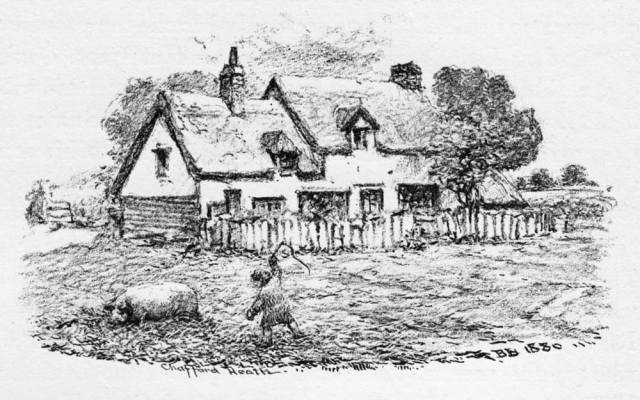
Chafford Heath Cottages from TL Wilson’s History, (1881)
In 1819 Chafford Heath Farm was part of the sale of the Esdaile family’s properties, when it was leased by John Hill or Hills, who also farmed at Heath Farm (see below). By 1842 it had been incorporated into the adjacent Bush Farm.
Bush or Bushes Farm was the largest farm in south Upminster, extending to 110 acres in 1799 and 129 acres by 1808, before Chafford Heath Farm’s 11 acres were added, stretching south from Harwood Hall and Sullens, and from Aveley Road in the west across to the Green Lane in the east.
The earliest references to the name are to Bushes, rather than Bush, Farm. In his Place-Names of Essex Reaney suggests that this name may come from one Laurence Busshe, mentioned in Upminster in 1327.
Like many Upminster estates, Bushes was owned by London merchants from the 16th century onwards. In 1570 it was the property of Joan Lowen, widow of John Lowen, citizen and draper, who just before his death in 1559 had bought the manor of Gerpins in Rainham, just across the border from Upminster. It’s possible that Joan inherited Bushes from her father John Plummer, another London draper, who before his death in 1534 owned copyhold lands in Upminster. Joan willed the estate to her sons Thomas and John Lowen and it passed down through two more generations to her great-grandson Dr John Lowen (c.1614-1679), a London Barrister. In his will Dr Lowen left an annuity of £30 to his sister Susanna out of the freehold and copyhold lands of his farm or mansion house called Bushes “where she drew her first breath” (i.e. where she was born). Dr Lowen’s properties seem to have passed to his nephew Daniel Gregory, a London stationer, but by 1694 Bushes was owned by Abraham Taverner. On Taverner’s death it was inherited by his wife Susanna and his daughter Susanna Harrison. The latter was also listed as the owner in 1704, along with John Franks and his wife Anne, and Thomas Roberts and his wife Susan. Bushes then comprised a copyhold tenement and 20 acres, together with another small parcel of land called Bushes Heath, both occupied by Thomas Arnold.

Bush Farm – courtesy of LB Havering Libraries – Local studies
By 1725 the owner was Peter Theobald (1656-1742), a prosperous Lambeth timber merchant, with George Southern the tenant. Bushes also then included an estate of around 60 acres which Theobald had bought for £650 in 1717 from Richard Dyott of St Giles in the Fields. This farm included three former ancient holdings, each of which comprised a house and land, named Giblotts (35 acres), Spackmans alias Comyns (10 acres) and Hydemans (10 acres), all occupied in 1704 by Richard Reading.
When Peter Theobald died in 1742 he was succeeded by his son, also named Peter (1694-1778) who in the following year enfranchised these properties, converting them from copyhold to freehold. Peter Theobald’s wife Elizabeth had the use of the properties during her life and after her death in 1780 they passed to their daughter Elizabeth and heir. In 1782 Bushes and the Theobalds’ other Upminster properties were advertised for sale and in January 1783 Sir James Esdaile bought them for £3,300 from Elizabeth Theobald.
When the Esdailes sold Bushes Farm in 1819 the farmhouse was described as “a very substantial brick-built house, containing three attics, four good bed rooms, two front parlours, kitchen, washhouse and cellars”. The farm buildings included “two barns, stables, cowhouse, granary, poultry house, cart and cattle sheds”. In 1856 Wilson said that the farmhouse had been partly rebuilt, and that carpentry at the back part was of the 16th century.
In 1749 the occupier was named as John Ramsden, who had probably farmed there since 1745 or earlier. John Banks was the occupier from 1765, and on his death in 1782, his widow Sophia succeeded him. Thomas Banks, presumably their son, took over after his mother’s death in 1791 and was still the farmer when John Russell of Stubbers bought the farm. In 1842 James Parker was the farmer and after his death in 1845, his son James (d.1850) and then James’ widow Ann were the occupiers. In 1851 Ann farmed 147 acres, employing seven men, on behalf of Champion Branfill Russell, and after she died in 1863 her son-in-law Charles Tween (1829-1916) carried in as the Russell’s farm bailiff. Tween seems to have retired around 1905, moving to live at The Cottage, Stubbers nearby and Stephen Collins took over as farm bailiff. Edwin Bonnett was the market gardener and farmer in the 1930s.

Report on the restoration after gravel working at Bush Farm
Like much of south Upminster, Bush Farm was excavated for the underlying gravel from the 1960s onwards. Afterwards, from the late 1970s, this site was part of a nationally-significant study which examined, identified and established a means of restoring such gravel quarries back to productive crop-growing. Previous infilling processes usually left sites mainly unusable and the methods successfully developed by this study are now a model nationally. Gravel extraction has still however left its mark on the landscape. One of the former gravel pits is now a 4.5 acre lake and a carp fishery, while in another is home to a Delta Force Paintball Centre (said to be “one of the best in the country”) offering “six massive battle arenas” and “plenty of action-packed scenarios and missions for you to try and conquer”.
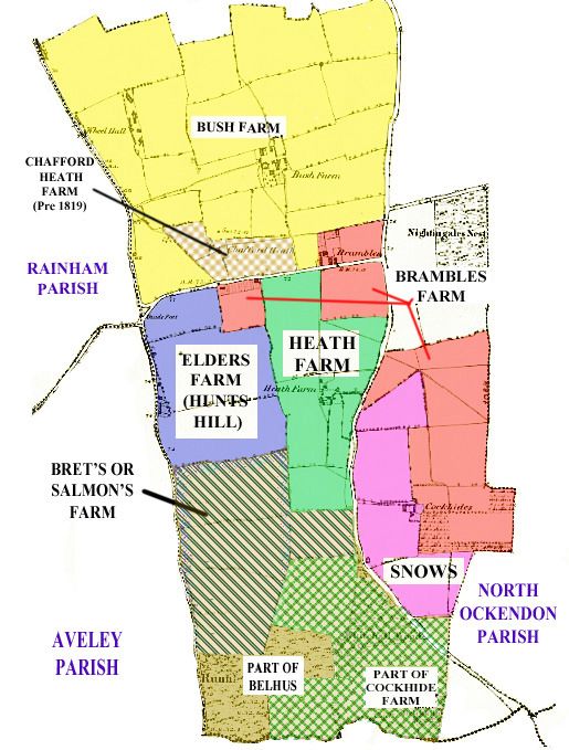
Archaeological investigations of the Hunts Hill Farm site, whose fields run south from Bramble Lane and along Aveley Road, have indicated that this is an ancient site of national and regional importance.
Impressive crop marks identified in the fields in the 1970s suggested field systems and enclosures, which indicate that the site was worth investigating further. After planning permission to extract gravel was given in 1987 steps were put in hand for archaeological investigations which began in 1989, ahead of gravel removal, and continued across a wide area until 1997.

Gravel extraction at Hunts Hill farm (1994). Image courtesy of LB Havering Libraries – Local Studies
Many exciting discoveries across this large 40-acre site show evidence of intermittent occupation or activity from the late Mesolithic era to as late as the medieval period, and even later. Sites of this size with an almost unbroken evidence of occupation are extremely rare. These finds were described as giving “a unique snapshot of a whole chunk of landscape …. (which) provides us with a better understanding of the archaeology of the southeast and in turn the rest of the country”. Large finds of late Iron Age and Roman pottery were significant as few groups of this period from this area have been found; important Saxon and medieval pottery was also unearthed. Excavations have also revealed remains of a large medieval farmstead or hall house and other outbuildings within a ditched enclosure, dated to the period c1100 to c 1225, as well as evidence of mixed arable and livestock farming. This complex has been tentatively identified as being a manorial complex that may be Brooklands which in 1400 comprised 100 acres in Upminster. This may be the third Upminster manor which in the Domesday survey was one and a half hides in extent, approximately 180 acres. If correct, this manor could possibly have occupied almost the whole of Upminster south of Brambles Lane.
The origin of the “Hunts Hill” name is unknown: it was not mentioned in either of Wilson’s parish histories and the earliest reference I can find is in the 1841 Census. Aveley Road slopes downhill here towards Running Water Brook, the watercourse which runs through the Belhus Woods site and which marks part of Upminster’s boundary with Aveley, but it’s unclear how it gained the “Hunts” part of the name. The Hunts Hill Cottages were initially built, probably around or soon after 1800 by an enclosure from the road side waste. By 1842 there were two cottages owned by Thomas Banks, one occupied by John Beard, thatcher.
Historically, Hunts Hill Farm was called Elders through to the late nineteenth century. Like Bushes it was owned by Peter Theobald and in the 18th century it was combined with another small farm to the east of the Green Lane, often called Snows. When Elders and Snows were sold by auction in 1782 they were both bought by Sir James Esdaile, along with Bushes.
Elders seems to have been assembled by Peter Theobald from two estates, both were named “Helders” in the Gaynes manorial records. The larger one in 1704 comprised four crofts and 35 acres, owned by Mrs Mary Pauncefort, widow, and occupied by Richard Reading. In 1725 the same holding was described as a tenement and eight crofts of land also named “late Roger Taverners” owned by Mr Grimbald Pauncefort, held by William Warden. Theobald was the owner by 1729 and like his other Upminster properties Elders was made freehold in 1743.
The smaller Elders holding was in 1704 a freehold messuage and lands, “late John Tomlins”, owned by Richard Spicer, miller, and occupied by Peter Newman; in 1725 Widow Fisher owned this. By 1749 it was also part of Peter Theobald’s estate and was “late in possession of Nehemiah Rogers, now John Rogers”. The copyhold parts were enfranchised by Peter Theobald junior after he inherited the farm from his father in 1743.
When Sir James Esdaile bought Elders in 1783 it was then farmed by Thomas Tabor of Dagenham, who had occupied it since at least 1770. After Tabor’s death in 1788 his son Bartholomew took over, and his widow Sarah took over after his death in 1799. Henry Blackman held the lease in 1808 and also in 1819 when the premises was bought by Thomas Barrett Lennard. Unlike many farms the field names retained its historical title and in 1842 three of the four fields included the name Elders.

Extract from TL Wilson’s copy of Upminster Tithe Map (1842) – south Upminster (Courtesy of LB Havering Local Studies)
Directly to the south of Elders was a 40-acre farm described as Brets when it was offered for sale by private contract in 1806 and 1807. John Salmon, who was then the tenant farmer at an annual rent of £27, had succeeded his father Richard around 1783. According to Wilson, the Salmons, father and son, had farmed there from 1745, and the parish poor rates confirm that Richard “Sermon” succeeded John Stamper in that year. In 1799 the owner was named as a Mr Brockis, who appears to be William Brockes of Hornchurch who died in 1806, with his wife Mary inheriting his estates. Brockes possibly also owned Damyns Hall in Rainham parish on the opposite side of the main road, as the two were offered for sale together in 1806 and 1807. The premises appear to have remained unsold until they were bought in 1824 by Sir Thomas Barrett Lennard, who amalgamated this with Hunts Hill which he had bought in 1819. In 1842 John Mitchell was the farmer of the combined farm of 66 acres.
The Salmons’ farmhouse was located in an adjacent field to the east, named Whitehall Piece, which they also farmed. In 1820 this was named as “Whitehall or Salmon’s Farm” which was described as “a timber and plaister and thatched tenement, cow-house and barn (in indifferent repair”, located just north of the apex of Whitehall Wood.

Whitehall Cottage (Picture credit with acknowledgment to A. Grant)
Snows lay opposite, to the east of the Green Lane, with Heath Farm to the west and Brambles Farm to the east. It was certainly owned by Peter Theobald in 1774 when it was farmed along with Elders by Thomas Tabor and when it was sold in 1783 the former occupiers were said to be Edward Martin and Ralph Snow, and later John Ramsden. It probably took its name from this Ralph Snow or from James Snow who was rated in Upminster from the 1740s.
It formed part of Sir James Esdaile’s 1783 purchase and when it was bought in 1819 by Sir Thomas Barrett-Lennard it comprised 29 acres, farmed by Henry Blackman. The farmer in 1842 was Phillip Brown, who also farmed other nearby holdings for Barrett-Lennard. It was also described as Blue House or Snows in 1819 and Snows or Blue House in 1842: the farmhouse, which was on the border with Brambles, is confusingly named as Cockhide on the Tithe and OS maps.
Heath Farm, which ran south of Bramble Lane to the west of the Green Lane, took its name from a family of the same name who owned it from at least the late Tudor period, possibly much earlier. Alternatively, it’s also possible that the family itself took their name from the nearby heath as there is a reference to William att Heth in 1503.
The first confirmed owner was George Heath of Upminster who in 1603 referred to his copyhold lands and tenement held of the Manor of Gaynes in Upminster called “Heathes”. It’s also likely that the copyhold lands in Upminster mentioned by a John Heath forty years earlier in 1563 was this farm.
Heath’s passed down through the family until it was sold in 1703 by George Heath, a grocer from Grays to John Cowland senior of North Ockendon. In 1704 the farm comprised 30 acres, plus a cottage and garden, all occupied by Ann Holman, widow. After John Cowland and his son of the same name died in quick succession in 1705 and 1707, Sarah Cowland, widow of John Cowland junior, inherited Heath’s.
By 1725 William Warden was the farmer and the cottage had been converted to form a barn. After Sarah Cowland died in 1743 her nephew John Stamper of Corbets Tey and her niece Sarah, wife of John Finch of Billericay, were the beneficiaries.
John Hills was the tenant from around 1790. He was most likely the father-in-law of Roger Beard who succeeded Hills as tenant. Roger Beard was described by Wilson as “a famous thatcher”, who also recorded that John Hills was also a thatcher who worked for George III at Windsor In 1842 Heath’s was a farm of 38 acres, and also included three fields (17 acres) adjoining to the south, leased from Sir Thomas Barrett Lennard of Belhus. Beard was living at Heaths in both the 1841 and 1851 census and was described as a farmer of 56 acres employing three labourers; he died in 1855 and his wife the following year.
Heaths was never owned by Sir James Esdaile, nor his family. After passing through members of the Finch family it was bequeathed in 1818 by Thomas Finch to his daughter Elizabeth Wood, wife of Thomas Wood of Billericay Mills; she converted the farm from copyhold to freehold in 1841.
After Elizabeth Wood died in October 1853 her son Thomas inherited Heaths and Thomas Circuit, a market gardener of Bedfordshire origins, probably bought the farm from him. Circuit had been described in 1850 as one of the largest onion growers in the south-west division of Essex. When Circuit took over Bramble Farm, he converted the farmhouse into tenements for the farm labourers.
Thomas Circuit died at East Ham in December 1867 and his son John Cubis Circuit succeeded him, continuing his father’s business as a leading Essex market gardener. In 1871 J C Circuit was living at Brick House, Rainham, which his father had leased from around 1850, and he was described as a landowner and farmer of 775 acres, employing over 250 hands – 184 men, 51 boys and 22 women. Sadly, he died, aged only 32 in 1876, but Circuit’s farms appear to have been held for over 30 years after that by trustees. The new owner appears to have been John Poulter, an Ilford dairyman and cow keeper, who paid £1,850 for Heath Farm in February 1909; Richard and William Eve were the tenant farmers from that year onwards.

Extract from 1805 Ordnance Survey 1″ Map
Circuit also owned Brambles Farm, adjacent to Bushes, which was 55 acres in extent. His father Thomas had bought Brambles around 1848 and eight years later Wilson wrote that “the variety and intermixture of crops present a singular and interesting experience”.
There is no evidence that Brambles was owned by Sir James Esdaile or his family, nor held as part of Gaynes Manor. Thomas Smoothy was the occupier from around 1770 and Edward Meredith succeeded him around 20 years later until his death in 1812. Wilson indicates that Smoothy and Meredith owned Brambles but the evidence suggests that they were probably both leaseholders.
Wilson also indicates that Thomas Marshall had bought the farm in 1817, but it seems to have been owned by him as early as 1799. Marshall seems to have been a prosperous Whitechapel cheese monger who, in later years, retired to live and farm at Brambles until his death in 1848.

Bramble Farm (Courtesy of LB Havering Local Studies)
Brambles Farmhouse is a Grade 2 listed building, dated from the early 18th century, with 19th century extensions to the rear and alterations to the gables. Wilson wrote in 1881 that Brambles had twice severely suffered by fire. One occasion was in 1844 when a spark from a chimney set fire to a thatched roof of a barn, destroying outbuildings, a large quantity of wheat and farm implements. Circuit had built two well-designed double cottages on the farm by 1856 which Wilson considered offered better accommodation than other local old cottages, at a cheaper rent.
Like Heath Farm, Brambles had also been bought by John Poulter from Circuit’s trustees in February 1909 for £2,800; Richard and William Eve were also the tenant farmers there. In 1910 Heath and Brambles combined included two houses, five cottages, and farm buildings.
South Upminster farms, around 1820. (Map courtesy Andy Grant(
Cockhide Farm was partly in Upminster, partly in North Ockendon and partly in Aveley and this has led to some confusion, which is complicated by the fact that the boundary between Upminster and with North Ockendon here appears to have changed after 1700, with several fields, part of Cockhide, becoming part of North Ockendon.
The earliest references to Cockhide noted by Reaney are in 1553 to Cokehedes Crofte and Cocke Hedd in 1556, which may relate to a local name for a wild plant, possibly red clover, knapweed or roundwort.
Wilson shows that in 1676 my ancestor Aaron Benton was rated for £30 for Cockhide in Upminster, no doubt the part of Cockhide Farm that lay in the south-east corner of the parish.
In 1619 much of the farm appears to have already been part of the Belhus estate owned by Sir Thomas Barrett Lennard’s kinsman Sir Edward Barrett. In 1700 Thomas Moyse of Hornchurch sold to Dacre Barrett premises named Cockhide alias Cockhead, which Moyse’s relative Ann Moyse had bought in 1672 with other Upminster premises from Samuel Gardiner, Doctor of Divinity, who received them as part of his marriage settlement with Alice Wincott in 1650. Cockhide was then said to contain 16 acres in North Ockendon, presumably the same property from which Thomas Frith had established in 1610 an annuity of £4 10s out of the rentals to provide 1s 6d in bread every Sunday for the poor of Upminster. Cockhide was occupied by Samuel Fitch from 1783, and then by his brother Willis Fitch who in 1799 was rated in Upminster for 32 acres.
The 1650 marriage settlement indicates that a house had lately been built there. The Chapman & Andre Map of 1777 and the first series Ordnance Series map of 1805 both show Cockhide Farmhouse as laying just across the border in North Ockendon, north of Running Water Brook and to the west of the lane which then ran south from Whitehall Cottage. Sir Thomas Barrett Lennard closed off this lane after he bought Snows in 1819, completing his land ownership in the south-east of Upminster. The farmhouse in North Ockendon was probably then demolished, although fields there still bore the names Great and Little Cockhide and maps in 1842 and later show the name “Cockhide” alongside what was the farmhouse to Snows. Wilson states in 1881 that Cockhide comprised 30 acres and that the house was of recent origin.
Archaeological excavations in 1982 and 1983 in a field between Whitehall Wood and Little Brick Kiln Wood, identified from cropmark photographs, uncovered traces of a prehistoric field system and settlement. Activity or artefacts from the late Bronze Age through to the late Roman period, were found, as well as debris from a nearby post-medieval brick-kiln. The site may also mark an early/mid Saxon settlement site and complements finds at the much larger Hunts Hill site.
The area, although lacking the big houses and features of other part of Upminster may in fact be of more historical importance as the area of the earliest settlements locally.
With thanks to Andy Grant, Tony Fox and Simon Donoghue (LB Havering Local Studies) for their help with this article.
Main Printed Sources:
Thomas Lewis Wilson Sketches of Upminster (1856) pp87-90
Thomas Lewis Wilson History & Topography of Upminster (1881) pp156-160
Bush Farm Working Party, Department of the Environment Bush Farm Upminster: Final report 1982-1987 (1988)
Pamela Greenwood “A late Bronze-Age/early Iron Age field system and settlement at Whitehall wood, Upminster”, London Archaeologist 5 (1986) pp171-175
Pamela Greenwood, Dominic Perring and Peter Rowsome From Ice Age to Essex: a history of the people and landscape of east London (2006) particularly pp27-30
Julian Hill Whitehall Wood, Aveley Road, Upminster: a post-excavation assessment Museum of London Archaeology (2004)
Isca Howell and others Archaeological landscapes of east London Museum of London Archaeology Monograph 54 (2011)
WR Powell “Upminster” in A History of the County of Essex: Vol 7 (1978) pp.143-163
Dan Swift Hunts Hill farm: a post-excavation assessment Museum of London Archaeology (2004)
PH Reaney The Place-Names of Essex (1935) pp 131-133
Main Archive Sources
Essex Record Office:
- Manor of Gaynes – Court Books 1678-1847 – D/DZb 1 & 2
- Sale Catalogues – Gaynes Estate: 1808: (D/DHt E183); 1819 (D/DRu 18/31); 1929 (SALE/A1047)
- Upminster Tithe Apportionment 1841 – D/CT 373A
- Marriage Settlement 1650 & Indenture of Bargain & Sale 1672 – D/DL T1/769 & 794
- Miscellaneous estate papers, c.1650-1819, including sketch map of Fitche’s farm – D/DL E9
- Miscellaneous estate papers, c.1785-1853, including sale particulars of Brets – D/DL E10
- Various wills: George Heathe (1603) D/AEW 12/256; George Heath (1617) D/ABW 20/308; John Cowland (1705) D/ABW 78/288; John Cowland (1707) D/ABW 79/45; Sarah Cowland (1743) D/AEW 36/1/23
The National Archives:
Prerogative Court of Canterbury Wills: Joan Lowen (1571) PROB 11/53; Dr John Lowen (1678) PROB 11/356; Peter Theobald (1743) PROB 11/724; John Stamper (1753) PROB 11/802; & Peter Theobald (1778) PROB 11/1045

Pingback: Big houses and farms around Corbets Tey | Old Upminster